Questions arise as tall buildings invade once untouchable Nakuru Statehouse area
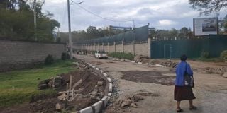
Area opposite statehouse that has undergone development in the last few months.

For ages, the stretch along State House Nakuru felt frozen in time with its quiet gate manned by officers, tidy lawns, and little sign of private investment.
Over the last 18 months, however, that stillness has been broken.
First came the tall, fortified mansion that is now the governor’s office, standing over the State House compound.


Soon after, a hotel that is whispered to belong to an influential figure is coming up, and now another multi-storey project is rising opposite an old car yard, directly across from the president’s quarters.
The pace of change has stirred conversation because, for decades, the neighborhood was 'assumed' to be a no-go zone for investors.
The presence of State House imposed an invisible barrier which has often been ‘silently’ spoken of against ambitious projects in the precinct, and was feared due to restrictions tied to security.
What could be built, and how close, was never entirely clear.
The law, however, draws a finer line, noting that the Protected Areas Act allows the government to gazette State Houses as protected zones, limiting access and use. But it does not in itself ban construction nearby.
A Nakuru urban planner, who requested to be anonymous, tells Mtaa Wangu that land-use and building control fall under the Physical and Land Use Planning Act, which is implemented by counties.
The planner familiar with the area explains that the recent surge of construction near Nakuru State House contradicts long-standing planning and security protocols governing development around such protected installations.
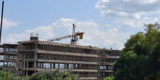
A section of the building believed to be a hotel being constructed in Milimani estate overlooking Nakuru statehouse.
According to them, State Houses, military barracks, police camps, and airports fall under a special category of ‘safeguarded or protected areas’, where development is heavily regulated to prevent security risks or visual intrusion into sensitive compounds.
They also point out that by law, no structure should rise high enough to overlook the State House, and that permits in such areas must undergo additional scrutiny involving national security agencies before approval.
Citing Sections 56 (g) and (h) and Section 60 (h) of the Physical and Land Use Planning Act, 2019, the planner explains that while the county government has the authority to process development applications for land near safeguarded areas, the final approval must include input or clearance from national security agencies.
They add that according to Nakuru’s approved city zoning plan, the area around State House (Milimani), where these new developments are taking place, is designated as a low-to-medium residential zone.
This classification allows for maisonettes and townhouses of up to only two floors, meaning any taller or large-scale projects would fall outside what the law permits.
In their assessment, some current projects breach these limits, both in height and how quickly they’ve been approved, suggesting that approvals may have been influenced more by power than procedure.
The planner adds that developers may be speculating, rushing to put up buildings ahead of the Rironi–Mau Summit highway construction, betting that proximity to the corridor will raise property values or increase compensation if future land acquisition occurs.
And while these unfold, they also caution that the law doesn’t foresee the State House relocating, given its symbolic and historical importance, making such proximity-sensitive planning rules permanent.