Worry as heavy rains destroy section of Ngata bridge-Kabasis road

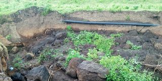
Ngata Bridge–Kabasis Road that is deteriorated after heavy rains exposing water lines. Photo taken on May 21,2025.
Immediately after branching left, off the highway to Kabasis at Ngata Bridge, you are greeted by a murram road. A few meters in, a noticeable transformation is noticed not figuratively, but quite literally.
The road appears to be narrow, and the boundary between the road and the reserve seems to be collapsing, a clear sign of the ongoing land sinking in the area.
As one moves further, it becomes evident that this is part of the broader earth-sinking that has affected various parts of Nakuru in recent years.
The sinking has exposed critical infrastructure such as water pipes and soil layers, often leading to blocked storm water drains.
During the rainy season, this situation worsens significantly. Several houses, farmlands, and road sections have sunk, causing damage and displacing residents.
The Ngata Bridge–Kabasis Road has drawn attention online, with images of its deteriorating condition warning motorists to exercise extreme caution.
In response to the threat, the county in collaboration with Rift Valley National Polytechnic have begun filling the gaping sinkholes that recently damaged large sections of the road following heavy rains.
These sinkholes posed a major safety hazard to both motorists and pedestrians, prompting emergency backfilling operations to restore road safety.
While these efforts offer a temporary fix, the recurring sinkholes highlight the urgent need for a long-term solution. Without a sustainable approach, the community will continue to suffer losses from damaged infrastructure and displaced livelihoods.
A proactive strategy is essential to prevent further land sinking and ensure the safety of the residents.


