Why Nakuru has experienced fissures in the recent past

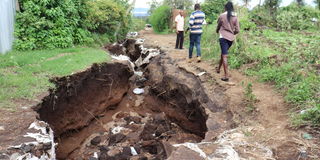
Pedestrians walk along the gulley that formed in Rongai after heavy rains were experienced on May 6, 2024.
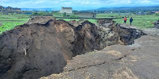
A few weeks ago, residents of Ngata, Sobea, RVIST and Kaptembwo woke up to find large gaping holes, stretching up to 40 meters in diameter and several feet deep.
For those in Kaptembwo, the extent of damage caused by this natural disaster was so severe that they had to be evacuated from their residences.
But just how do these occurrences come to be?
According to Professor Gilbert Obwoyere, “Nakuru is located on the floor of the Rift Valley and any form of weakness would show itself all the way to the surface.”
According to the Professor, these fissures are formed when water finds an entry through the ground clearing the soil in its path.

A fissure that formed in Kiamunyi following heavy rainfall on April 22, 2023.
“Water erodes forwards and backwards and as it moves if it finds a barrier, that is a hard material that cannot be eroded. It then moves upwards and hence you get to notice they become large round pits” he says.
He adds to this by saying this is not the first time this is happening. In 1992, a similar scenario occurred around the Eveready area.
“The split is occurring along a contour from Menengai, Sobea, Ngata, Kaptembwo Kiambogo all the way to Suswa.”
“In many cases such places where fissures have formed usually remain as a gulley, because filling them up with soil would take a great effort.
On what can be done to prevent these fissures, Prof. Gilbert says enhancing soil conservation in the upstream areas like Milimani, so as to avoid a lot of water finding its way underground is a good place to start.


