Mwariki A, Barut residents fear the worst as rains continue
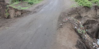
A section of a road in Barut eroded by rain water.

Mwariki A, known to be a pathway for storm water the devastation of the ongoing rains is evident everywhere.
The roads are partially flooded with water and the roadside drainage system is at full capacity.
As a result, motorists have to manoeuvre their way through rain-slicked roads.
For most of November, heavy rain has been falling in all parts of the country, with places like the Central Business District experiencing light showers for most of the day.

A section of a road in Mwariki.
The flood-prone areas of Nakuru were the first to suffer from the heavy rains.
"The county's preparation in constructing drains has gone a long way in ensuring that we can contain the situation, although the construction of some of these drains is not yet complete. And if the rains continue, we may end up with a serious situation," said Mwariki A District Chief Joseph Macharia.
According to Mr Macharia, flooding has always been a problem in the area. But the community is now more vigilant thanks to the sensitisation that has taken place.
In Barut, people fear a repeat of a natural disaster that happened a few years ago when Lake Nakuru burst its banks.
They fear that the lake's water level will rise again due to the continuous heavy rains.

A vehicle trying to pass a section of an eroded road in Barut.
Already, part of a road near a mining site has eroded, leaving only a narrow strip where only one vehicle can pass at a time.
Speaking to Mtaa Wangu, area chief Joseph Oyawa lamented the generally poor state of roads and drainage in the area.
"The roads are in a bad state; even small cars cannot get through. In addition, drainage systems have never been constructed in this area, so the situation is not good," said Mr Oyawa.
"We are lucky that Lake Nakuru has not flooded, but we need the government's support to help especially those who will be affected by the floods," he said.
When the Meteorological Department issued its first warning of the impending El Niño season in August, the efforts of both the national and county governments were focused on finding ways to deal with any disasters the rains might cause.
The county mapped out some of the areas that would be prone to flooding, including Dondori, Mwariki, Rhonda and Subukia.