El Niño preparedness: Nakuru county maps out danger zones

Rescuers push a stranded vehicle through floodwater near Eveready roundabout, Nakuru, after heavy rains left the car yards flooded

Nakuru County has pinpointed over 70 flood-risk zones as it ramps up disaster readiness before rains expected in October, which forecasters are attributing to El Niño.
Nakuru Town East and Nakuru Town West carry the heaviest concentration of danger zones highlighted with 15 sites each, followed by Njoro with nine, Naivasha with six, Gilgil with five, and Kuresoi North with four, spread across the county's flood-prone sub-counties.

Mud, silt and debris line the Eldoret estate after floodwaters receded, exposing damage to the drainage channel and nearby shopfronts

The county government says that they have set up rescue and evacuation points, while three hospitals, including the Nakuru Referral and Teaching Hospital, Naivasha Level 4, and Njoro Sub-County, have been earmarked to handle emergency cases.
This is in addition to 22 ambulances and three fire trucks put on standby to respond quickly once the rains hit.
The county's push for preparedness follows two years in which extreme water events have repeatedly upended lives across Nakuru.
In 2024, flash floods tore through several sub-counties in a matter of weeks, with Mtaa Wangu reporting that at least five families fled their homes and farms which were flooded by heavy rains, with maize farms in Salgaa, Rongai, submerged.
Days later in Kaptembwa, Nakuru Town West, more than 100 families fled their homes after flash floods caused deep gullies, mudslides and sinkholes, with residents blaming an incomplete drainage system left over from a land dispute.
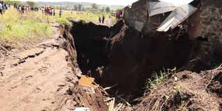
A house lies in ruins after a massive sinkhole opened up in Kaptembwa, Nakuru Town West, swallowing part of the structure as residents gather at the scene
Around the same time, a sinkhole opened up on a family's farm following the heavy rains.
The most devastating single event came in April 2024, when a blockage in a culvert beneath a railway embankment triggered a catastrophic failure near Mai Mahiu, killing at least 61 people, injuring 109 and leaving 37 still missing as of May 7.
Nationally, that April's floods caused an estimated Sh 4 billion in damage.
By late 2025, the crisis had shifted from flash floods to the relentless rise of Lake Naivasha that had travelled up to 1.5 kilometers inland into Kihoto village in November, submerging homes, churches and even a police station.
Nakuru County's Chief Officer for disaster risk management, Joyce Ncece, then estimated that 7,000 people had been displaced by the rising waters, with tourist boats repurposed to evacuate flooded households and children forced to leave school on makeshift rafts.
With forecasters signaling another severe rainfall season, the stakes for the county could not be higher and the success of these measures will ultimately depend on swift execution and seamless coordination when the rains fall.