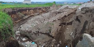
Rift in the City: Tricks and tips of reinforcing grounds prone to fissures

A fissure in Kiamunyi that has redeveloped after the county filled it up and is currently widening up now.
Geologists have attributed fissures and sinkholes to the continuous geological formations within the region, pointing to the fact that Nakuru lies on unstable grounds and lines of weakness on the floor of the Rift Valley.
However, despite the risks, Nakuru has continued to experience investors and individuals who sink fortunes in the establishment of business investment and development of residential homes.
And with such investment, the focus is no longer on running away from danger but knowing how to exist with the realization of the imminent disaster.
Gilbert Obwoyere, an associate professor of landscape ecology and ecosystem health notes that the tectonic plates movement and the rampant volcanic activity is the cause for the enormous underground fissures and lose volcanic ash that is the profile of the soil in the region.

Gilbert Obuyere, an associate professor of landscape ecology and ecosystem health during an interview at Egerton University.
He warns of the huge risk paused by the geological activities which he says are poised to continue occurring.
To reduce the magnitude of the risks, the professor advises that the first measure is to avoid going near the areas that have experienced the geo hazards, to avoid plunging into the deep sinkholes and gullies.
“Those who have seen fault lines and fissures along their fields should take precautions until they get a very concrete report from our geologist. If you see a hundred metres long gully from a single rainfall event, you should get worried,” notes Prof Obwoyere.
For an easy evacuation the geologist advises that the county government needs to provide a helpline number where the residents can report any geological risk.
“If any citizen notices anything that is unusual, they should make a report. Natural events do not take a lot of time before they explode and the more people know about it, the more they will be able to reduce the damage,” he says.
Improving landscape is another way of reducing the risk of the geo hazards which helps to reduce the amount of surface runoff.
Prof Obwoyere explains that there is a need to provide enough avenue for water to infiltrate to the underground by planting trees in the compound and covering the ground surface.
When the water finds a line of weakness, it seeps into the fissure where it erodes the underground as it flows up to a point where it finds a barrier thus erodes upwards, collapsing walls.
“Residents of these areas need to improve their landscape by having two to three trees on their soil, and let the soil be covered with grass. Where we have construction lets have proper channels to direct the water and with correct size,” says Prof Obwoyere.
The government further needs to construct proper drainage channels to reduce the amount of water that percolates and flows on the land surface.
The government has engaged the services of geologists from Geothermal Development Company (GDC) and Kenya Electricity Generating Company (KenGen) to carry out studies in the areas affected by fault lines across the devolved unit.
Mining Principal Secretary Elijah Mwangi, says the department’s geo-physicists has continued to enhance surveillance on other geological vulnerabilities that might occur.
Immediate intervention according to the PS is to avoid accumulation of excess water on the surface, through construction of adequate storm drains and waterways within the town and residential areas to allow free and fast flowing of water to destination water bodies.
