How Nakuru's rich trigger floods downstream

School children help each other cross a flooded section opposite Afraha Stadium on September 2, 2024.

“Before 2010, we did not experience the kind of floods we see today. However, around 2013, that changed,” Dennis Kunga begins.
Kunga has been a resident of Kivumbini estate for decades.
He continues to recall how back then, after a heavy downpour, large pools of water would accumulate near Bondeni police station, but then clear up after 30 minutes.


But this, Kunga says, is no longer the case.

Dennis Kunga during an interview with Mtaa Wangu.
“Now, after the rains, places like Ojuka near Baharini Primary School become impassable, creating a safety hazard for the school children,” he reveals.
What Kunga describes is not only the effects of climate change, but of urbanisation and increased population upstream.
According to the 2019 census, Nakuru county’s population stood at 2.16 million up from 1.6million in 2009.
During an earlier interview with Eng. Michael Kamau, the County Executive for Roads, Transport, and Public Works, he explained that the number of human activities upstream (areas of Milimani, London, Menengai Forest and city center) has overtime led to an increased water flow downstream (areas of Kaptembwa, Kivumbini, Manyani and Pondamali).
“Currently, we have paved more surfaces, built houses and other such activities. Therefore, the water that was absorbed by the ground now flows freely along the tarmac roads and pavements, since there is no ground to absorb it,” he said.
But Kunga is not the only one feeling the pain.
Beatrice Ng’ang’a a shop vendor in Pondamali says that most of the flash floods they experience is due to the storm water that flows from the city center finding its way to the lake.
“I understand that Nakuru generally is in the form of a slope and all the water that comes from the city center, Milimani and the Menengai forest finds its way to Lake Nakuru. However, in recent years, the volume of this water seems to increase. So bad is the situation, that the water often overpowers the existing drainage,” Beatrice narrates.
The water that flows downstream, carrying everything in its wake introduces a second problem; that of clogged drains.
Beatrice tells us that once the drainage clogs, the water floods the tarmac, eventually finding its way into homes and shops, destroying property in the process.
A spot check by Mtaa Wangu in parts of the market in Ponda Mali after heavy rains revealed that the area had flooded rendering the path ways impassable.
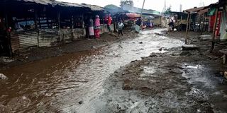
A market in Pondamali that was flooded after a heavy downpour on April 13, 2024.
Heading towards the Sewage treatment area, storm water was finding its way into the houses, forcing them to flee for safety and come back to assess the damage later.
For most of the people living here, the rains are more of a curse than a blessing.
Back in Milimani, new houses continue to sprout and with it comes well defined drains that can be seen outside the gates.
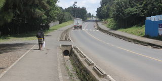
A well-defined drainage in Milimani directing water down stream. Photo taken on 17 August,2025.
These drains seemingly lead all the rain water in that compound to the drainage system outside, that then makes its way to Beatrice and Kunga’s homes.
Were this water to be collected and stored in all the homes upstream, it’s likely that flooding would significantly reduce downstream.
Jackson Raini, an environmental expert, confirms that Lake Nakuru is at the lowest point of the catchment area (the area from which rainfall flows into a river, lake, or reservoir).
Hence, increased volumes of storm water are also a result of the impervious surfaces (a hard surface that prevents or greatly reduces the infiltration of water into the ground).
“At the moment we have tarmac and cabros all over. Therefore, there is very little water that is being absorbed into the ground. As a result, a lot of rain water runs on the surfaces. This is very evident in the areas of London, Milimani and also in the city center,” says Raini.
The environmental expert also says the degradation of Menengai Forest is also a factor that has led to the increase in storm water over time.
This can easily be proven by the continuous and visible deforestation and advancement of construction witnessed in parts of the forest, thus eroding the forest cover.
Raini further acknowledges the fact that we have more intense rains and therefore there is a need to set up proper drainage systems.
“The challenge that we have in Nakuru is that we do not have a drainage master plan so that we know how to manage the storm water. We need a drainage city storm water master plan that will be able to address the issue especially as you head towards the downstream areas,” he says.
Mr Raini also mentions other interventions that could help people like Beatrice and Kunga.
“There is also a need to come up with a sponge city model that aims to absorb more water instead of channelling it to the low-income high density residential areas. Lastly, there is an urgent need for urban greening and conservation of Menengai forest,” he concludes.
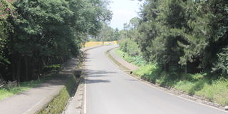
One of the scenic roads in Milimani estate, one of Nakuru's wealthiest address. Photo taken on August 17,2025.
During a phone call interview Eng. Michael says that indeed the issue of flooding after the rains is a major challenge the county is working to address.
“To effectively address the issue of flooding in Nakuru, we need to construct proper drainage systems. However, solving this crisis cannot be done by the County government alone; it requires a multi-sectoral approach involving various stakeholders,” he states.
He also adds that the county has mapped out some of the areas upstream and are working to construct proper drainages downstream that will guide the rain water safely into Lake Nakuru.